Amora Icons


Amora Icons

130 icons | 128×128 | ico & png | 12 MB

Download:
http://uploading.com/files/9c141546/amora-icons.zip/

Read more

Earthquake off Samoa Generates Tsunami

Earthquake off Samoa Generates Tsunami


on sept 29,  2009, a large undersea earthquake near Samoa generated a destructive tsunami that killed more than 100 people, said news reports. According to measurements from the United States Geological Survey (USGS), the magnitude 8.0 quake hit at 6:48 a.m. about 200 kilometers (125 miles) south of Apia, the capital of Samoa. The tsunami struck the islands of Savi’i, Upola, and Tutuila minutes later with waves that were 3.1 meters (10 feet) high near Pago Pago (American Samoa) and 1.4 meters (4.6 feet) in Apia, said the USGS. Smaller tsunamis hit other Pacific islands farther away from the quake’s epicenter. This image shows the location of the earthquake in relation to the islands. The earthquake epicenter, shown by a large black circle, was located on the Pacific tectonic plate near its boundary with the Australian plate (southwest corner of map). Dozens of magnitude 4 and 5 aftershocks, shown by open circles, followed the initial earthquake, continuing until at least September 30th. The knee-shaped area of deep water is the Tonga Trench, a deep canyon on the edge of the Pacific plate. The trench and associated faults are forming as the Pacific Plate moves westward, sinking beneath a complex series of smaller plates on the edge of the Australian plate, the shallower area in the lower left corner of the image. The region around the Tonga Trench is one of the most active earthquake regions in the world, said the USGS.
Read more

The flooding of the Nile Delta Gallery (12 pictures):

Nile Delta: A farmer pumps water from the canal onto his fields
1 / 12
A farmer pumps waste water on to his land as the Nile barely reaches it. The region is home to two-thirds of the country's growing population and provides 60% of its food supply 
Nile Delta:  Said Mohamed Shairwi fishes from the wall built to prevent coastal erosion
2 / 12
Rashida resident Said Mohamed Shairwi fishes from a sea wall built recently to prevent coastal erosion. In some places Egypt's coasts are being eroded at a rate of 100 metres a year
Nile Delta: A woman carries wheat to be threshed during an intensive harvest
3 / 12
A woman carries a large pile of wheat for threshing during an intensive harvest. Many women in the area take on seasonal day work for $3 an hour during busy harvest periods
Nile Delta: Abdul Fattah ploughs his field in Kafr El Sheikh before planting rice
4 / 12
Abdul Fattah ploughs his field in Kafr el-Sheikh, one of the worst-affected areas, before planting rice
Nile Delta: A young child who works on the fishing boats on Lake Burullus 
Nile Delta: A young child who works on the fishing boats on Lake Burullus
5 / 12
A young boy who works on the fishing boats on Lake Burullus
Nile Delta: An irrigation machine on a potato plantation outside Alexandria
6 / 12
A huge automated irrigation machine moves slowly through a potato plantation grown on reclaimed desert land outside Alexandria
Nile Delta: Labourers harvest rice from a paddy filed in Kafr El Sheikh
7 / 12
Labourers harvest rice from a paddy in Kafr el-Sheikh
Nile Delta: Mohammed 13, walks back home after working on his family's fields 
Nile Delta: Mohammed 13, walks back home after working on his family's fields
8 / 12
Mohammed, 13, walks home with his farming tools after working on his family's fields in the village of El-Haddadi
Nile Delta: New apartment buildings along side the Damietta branch of the Nile
9 / 12
Apartment buildings alongside the Damietta branch of the Nile, where the resort Ras el-Bar lies. Once a popular holiday destination, the holiday homes are now deserted 
Nile Delta: Polluted waste water from agricultural drainage pumped into the a cana; 
Nile Delta: Polluted waste water from agricultural drainage pumped into the a cana;
10 / 12
Polluted water from agricultural drainage and sewage is pumped into a canal leading out into the Mediterranean near Rashida
Nile Delta: A girl watches over water buffalo grazing in a field worked by her family
11 / 12
A girl watches over water buffalo grazing in her family's field
Nile Delta: Salt encrusted soil on a potato plantation near to el-haddadi village.
12 / 12
Salt-encrusted soil on a potato plantation near El-Haddadi village provides evidence of the problems of sea encroachment


Read more

Dust storms around the world (20 pictures)


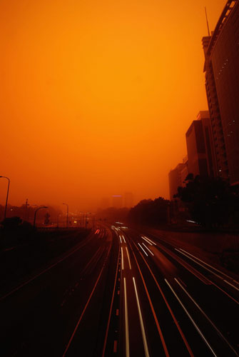
The Bradfield freeway, Sydney, on 23 September, 2009. Huge dust storms like the one which blanketed Sydney and turned the air red across much of eastern Australia this week are spreading epidemics and now reaching every country in the world, but could be absorbing climate change emissions, say scientists studying the little understood global phenomenon
Dust storm: Red dust storm hits Sydney, Australia - 23 Sep 2009
2 / 20
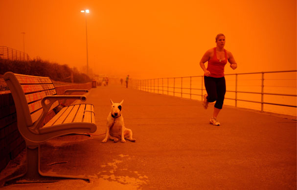
A runner passes a on Bondi Beach. Residents along Australia's east coast awoke to an orange, glowing sky as winds swept millions of tonnes of red dust from the country's drought-ravaged interior and dumped it on Sydney
Dust storm: A huge dust cloud rolls over the Australian town of Griffith
3 / 20
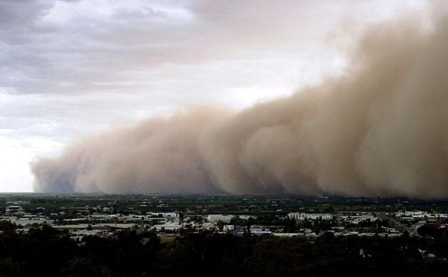
A huge dust cloud rolls over the Australian town of Griffith, 400km (248 miles) south-west of Sydney in 2002. Australia is in the grip of a 10-year-old drought that has been widely attributed to climate change and is turning large parts of the interior of Australia into a giant dust bowl
Dust storm: Red dust storm hits Sydney, Australia - 23 Sep 2009 
Dust storm: Red dust storm hits Sydney, Australia - 23 Sep 2009
4 / 20
Red dust trapped in a spider's web, Sydney, Australia
Dust storm: Huge dust storm raging over a desolate Texas farm
5 / 20
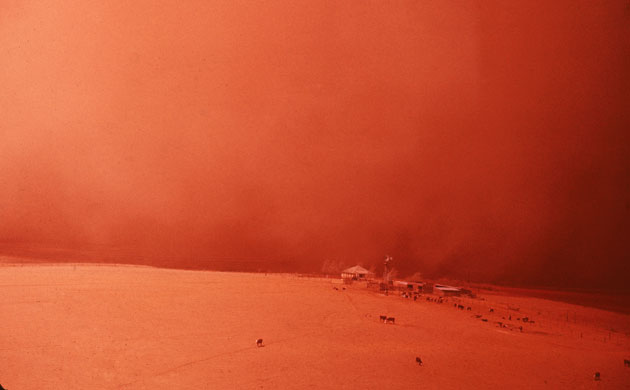
Dust storms are not a new phenomenon - this image, from 1955, shows a huge dust storm raging over a desolate Texas farm. Most dust storms are linked to long droughts, exacerbated by human activities like overgrazing and deforestation 
Dust storm: a dust cloud enveloping the Saudi capital Riyadh
6 / 20
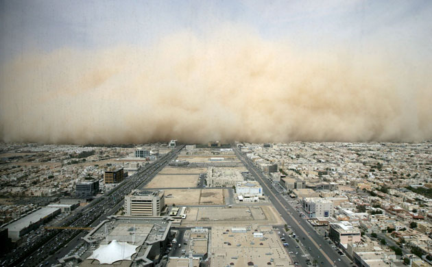
A dust cloud envelops the Saudi Arabian capital, Riyadh, in March 2009. This week meteorologists predicted that many more major dust storms would occur if climate change leads, as expected, to deeper droughts
Dust storm: Dust Storm Moves Across Egypt and Saudi Arabia and Red Sea
7 / 20
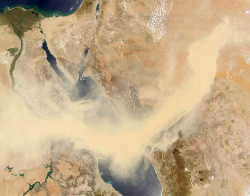
A satellite image from May this year shows a thick band of dust snaking across the Red Sea
Dust storm: Dust blows across the Mediterranean Sea
8 / 20
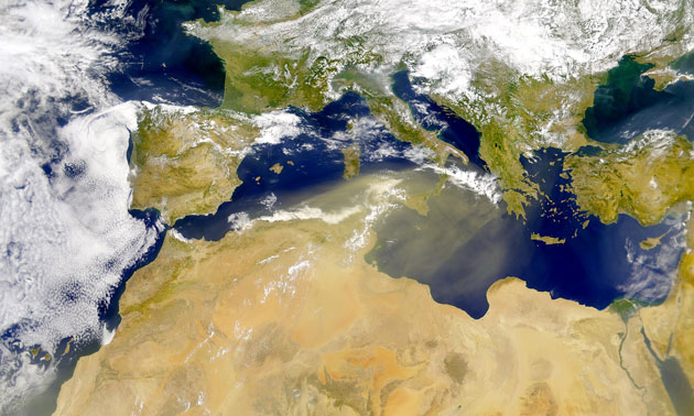
Dust blows across the Mediterranean from North Africa and across Sicily to western Greece. Dust blown from the Sahara desert reaches north of the Alps approximately once a month, according to the World Meteorological Organisation
Dust storm: Dust Storm Over China 
9 / 20
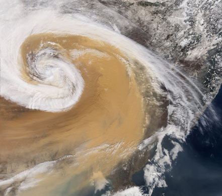
An enormous dust cyclone swirls over north-eastern China (the northern Korean peninsula is bottom centre). The cyclonic cloud is actually pushing a wall of dust, which covers the land beneath, and even over some of the clouds. Witnesses report that it was as dark as night, and dust was pushed as far as the Great Lakes of North America
Dust storm: A Chinese farmer walks amid a sand storm in Minqin County, Gansu, China
10 / 20
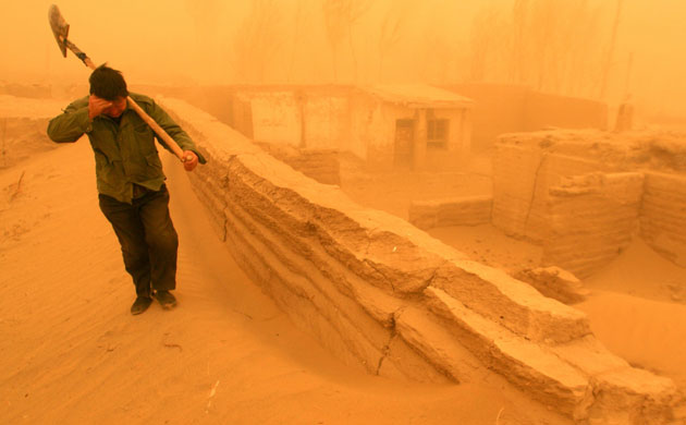
A Chinese farmer walks amid a heavy sand storm in Minqin county, in China's Gansu province. Northern China, parts of the US, the Sahel in Africa, the Middle East and Australia are all prone to severe dust storms which routinely travel thousands of miles and on occasion have been found to travel twice round the world in the upper atmosphere. Chinese scientists have linked the increasingly severe storms of the last decade to massive deforestation and over-exploited water resources in southern and eastern China
Dust storm: Sandstorm Covers Beijing Overnight
11 / 20
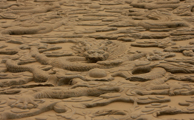
Carving in the Forbidden City in Beijing, China, is covered with a layer of dust, blown from a sandstorm which hit the China-Mongolia border in April 2009. Residents found their homes, streets and cars covered in brown dust. Residents were advised to stay indoors or wear masks when going out 
Dust storm: Sand,storm at an Oasis Kerzaz, Algeria
12 / 20
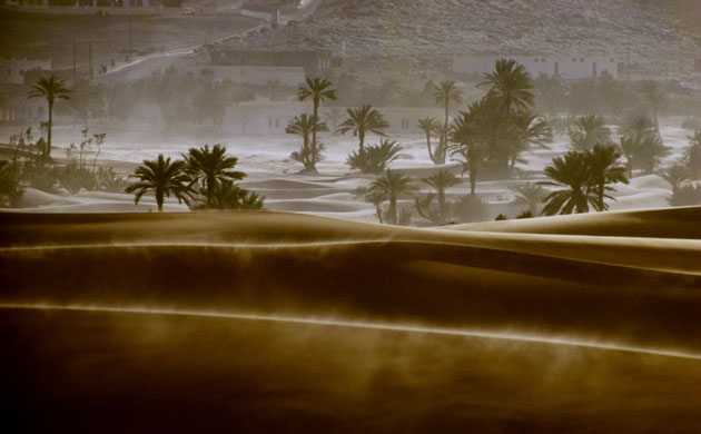
Kerzaz, Algeria. The sandstorm season in the Sahara runs from March to April. The range of Saharan dust storms, which mostly start in Chad, can carry fine dust across the Atlantic to the Caribbean and the US. They have increased dramatically since the 1950s, causing massive topsoil loss and reducing food supplies in Niger, Chad, Nigeria, and Burkina Faso 
Dust storm: An unripe orange and leaves are covered in sand after sand storm, Baghdad,
13 / 20
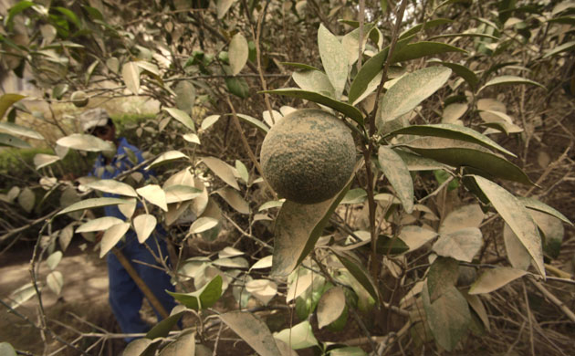
An orange tree covered in sand and dust in Baghdad, Iraq, in July. Sand storms, the strongest and densest in years, have plagued the country this summer. The country, which is in the middle of a three-year drought, experienced 18 days of dust storms 
Dust storm: Sandstorm in Wadi Mur, Tihama, Yemen
14 / 20
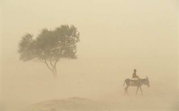
Yemen, 2003. A boy riding a donkey is almost swallowed by a sandstorm in Wadi Mur
Dust storm: Tree in Sand storm on Niger River
15 / 20
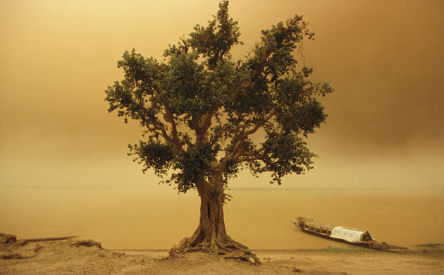
Mali, 2001. A tree weathers a sandstorm. The Sahara desert is a key source of dust storms, particularly in the area covering Mauritania, Mali, and Algeria
Dust storm: Mali Women Caught in Sand Storm
16 / 20
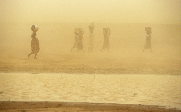
Mali, 2001. Women caught in a sand storm. Dust storms cause soil loss - in particular the loss of the nutrient-rich lightest particles - reducing agricultural productivity
Dust storm: Afghan refugee child hides from a dust storm
17 / 20
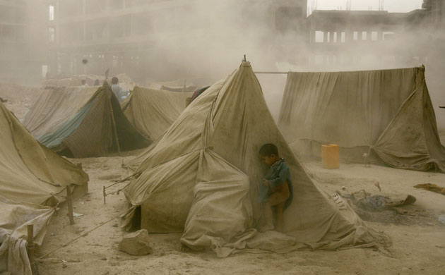
An young Afghan refugee hides behind a tent from a dust storm in Kabul on in October, 2008
Dust storm: a sandstorm along the Utah-Arizona border
18 / 20
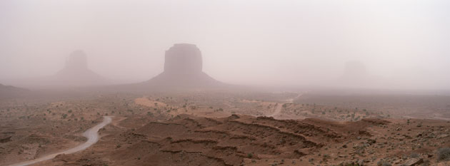
The Mittens, Monument Valley, during a sandstorm along the Utah-Arizona border
Dust storm: dust storm over Drought-ravaged Patagonia , Argentina
19 / 20
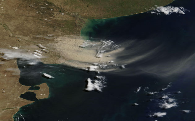
Continuing an intermittent pattern from the previous month, more dust plumes blew off Argentina's coast in February, forming slight arcs that move in a counter-clockwise direction over the Atlantic Ocean. This part of Argentina is also known as Patagonia, with arid landscapes sculpted by relentless winds. The dry conditions were exacerbated in early 2009 by the worst drought in a generation. The source of the plumes appears to be an agricultural region north of Golfo San Matias
Dust storm: Dust Storm in the Sahara Desert 
20 / 20
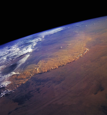
May, 1992. View from the space shuttle Endeavour of a huge dust storm in the Sahara desert, which covered hundred of miles in Libya and Algeria.


Read more

Red river floods in Minnesota Gallery (14 pictures):

Red River floods: Brian Witthoeft works to keep out the rising Red River flood waters
1 / 14
25 March: Brian Witthoeft works on a retaining wall to keep out the rising waters from reaching his home in Moorhead, Minnesota
Red River floods: Local men struggle in the snow to unload a boat full of sandbags.
2 / 14
25 March 2009: Volunteers struggle in the snow to unload a boat full of sandbags at a home in Fargo, North Dakota 
Red River floods:  John Iverson wades through icy water after leaving his home in Oxbow.
3 / 14
26 March: John Iverson wades through icy water after leaving his home in Oxbow, North Dakota. Water from the Red and Wild Rice Rivers had started to overtake the small community, about 15 miles south of Fargo 
Red River floods: Steam rises off clay being excavated for dykes in Fargo.
4 / 14
27 March: Steam rises off clay in what used to be Centennial Fields, as heavy equipment excavates material to build earthen dykes along the Red river, in Fargo
Red River floods: Pete Babler inspects a levee along the flooded Red River.
5 / 14
28 March: Pete Babler inspects a levee for leaks in the Harwood Grove neighbourhood in Fargo
Red River floods: A house is protected by sandbags from flooding of the Red River, Minnesota.
6 / 14
28 March: A house near the Oak Port neighbourhood on the northside of Moorhead is protected by sandbags from flooding 
Red River floods: North Dakota's Red River Valley prepares For flooding
7 / 14
28 March: Members of the Horace fire department, the North Dakota national guard and volunteers help to sandbag a retention pond to keep flood water from the water treatment facility near Horace, North Dakota
Red River floods: National Guard personnel walk in the high icy floodwaters.
8 / 14
28 March: National guard personnel walk in icy floodwaters as they try to evacuate residents in Fargo
Red River floods: Minnesota National Guard wades through water with supplies to home owners
9 / 14
28 March: Verne Parks of the Minnesota national guard wades through the water to bring supplies to people in Oakport, Minnesota
Red River floods: Moorhead, Minnesota is seen inundated by floodwaters.
10 / 14
28 March: Moorhead is inundated by floodwaters as the river continues to rise
Red River floods: A road is covered by floodwaters with a Stop sign still visible.
11 / 14
28 March: Only a stop sign is still visible on a flooded road in Fargo
Red River floods: North Dakota's Red River Valley Prepares For Flooding
12 / 14
28 March: Just inside a sandbag levee, Jonathan Robbins checks on a pump which is removing flood water seepage in Fargo
Red River floods: Jared Bakko hauls a boat down a flooded road after delivering supplies.
13 / 14
28 March: Jared Bakko hauls a boat down a flooded road after taking supplies to his grandmother, just south of Moorhead
Red River floods: Homes are surrounded by floating ice and floodwater as the Red River rises.
14 / 14
28 March: Homes are surrounded by floating ice and floodwater in Fargo. The normal banks of the river are defined by the twisting tree line


Read more

Against the waves: Flood defences in Bangladesh Gallery (7 pictures)

Bangladesh flood defences: Men stand in line, sending mud up to the embarkment
1 / 7
Men stand in line, sending mud up to the embankment. They are trying to build a new and stronger flood barrier after tropical cyclone Sidr destroyed the old one in 2007
Bangladesh flood defences: Thousands lives on the embarkments surrounding the island Padma Pakur
2 / 7
Thousands live on the embankments surrounding the island of Padma Pakur in the south of Bangladesh. On the left side is the ocean, on the right the flooded island, which used to be villages, cultivated land and fishing farms
Bangladesh flood defences: Men pass mud along a line
3 / 7
Men pass mud along a line as they build an embankment by hand on the island of Padma Pakur
Bangladesh flood defences: Sale Ha Begum builds a tent for herself and her son
4 / 7
'The flood barriers are not able to prevent the flooding any more. I am afraid we will not be able to move back home,' says Sale Ha Begum. She is building a tent for herself and her son on the embankment. Since May, thousands have been forced to live on the narrow flood barriers in tents and temporary cabins
Bangladesh flood defences: Between the beach and the town, huge areas are planted with trees
5 / 7
Between the beach and the town, huge areas are planted with trees to prevent erosion and act as a shield against winds

Bangladesh flood defences: After a day of fishing in Bengal Bay, the boats returns to the beach
6 / 7
After a day of fishing in Bengal Bay, boats returns to the beach. The water is coming closer to land, causing erosion along the longest beach, Inani beach. The government tries to prevent the erosion by planting trees and reinforcing the embankment
Bangladesh flood defences: Men and women fish along the embarkment
7 / 7
Men and women fish along the embankment. It is one of the few ways the local population is able to get food and a small income


Read more

Philippines floods: hundreds dead or missing after storm (pics of philippines)

Philippines floods: A Filipino resident holds his pet dogs, trapped by floods


A resident trapped by floods brought by tropical storm Ketsana is evacuated to higher ground with his pet dogs in Marikina City
Philippines floods: Filipinos wade through floods caused by tropical storm Ketsana in Cainta


Filipinos wade through floods to higher ground at Cainta, east of Manila


Philippines floods: Residents wade in floodwaters in Cainta Rizal east of Manila


Residents wait for evacuation from Cainta Rizal, east of Manila
Philippines floods: A survivor of floods washes his family's soiled belongings in Silangan


A flood survivorwashes his family's soiled belongings in Silangan village, north of the capital, Manila

Philippines floods: A group of men attempt to move a car as flood waters recede


Men try to move a car as flood waters recede in Marikina City, near Manila

Philippines floods: Filipino rescuers evacuate flood victims in Pasig City, east of Manila


Filipino rescuers evacuate flood victims in Pasig City, east of Manila


Philippines floods: Filipino flood victims receive packs of goods during a relief operation


Filipino get packs of goods during a relief operation in Pampanga province, north of Manila

Philippines floods: Filipinos are drenched in mud as they recover belongings from damaged homes
Filipinos are drenched in mud as they try to recover belongings
from damaged riverside homes in San Mateo,
Philippines floods: Filipinos plead for help as they evacuate a flooded hospital in Cainta


Filipinos plead for help as they evacuate a flooded hospital in Cainta, east of Manila
Philippines floods: Residents wait for evacuation from floods in Cainta Rizal, east of Manila
Read more

Satellite eye on Earth:part 3(pics)


On 24 September, the dense dust that had covered eastern Australia the previous day blew south over the Tasman Sea towards New Zealand. The dust plume is still densely concentrated in this image, highlighting the strength of the winds. The lower half of New Caledonia is visible along the top edge of the image. Hidden by clouds, the northern shore of New Zealand's South Island is outlined in the lower right corner of the image
Satellite Eye on Earth: Farming fields, northwest Minnesota , US 
From space, north-west Minnesota looks like a patchwork quilt. Fields change hue with the season and with the alternating plots of organic wheat, soybeans, corn, alfalfa, flax, or hay

Satellite Eye on Earth: Fires burned in and around Mozambique 

Fires burned in and around Mozambique in mid-September. At this time of year, near the end of Africa's dry season, the region glows with agricultural fires and wildfires. In this true-colour image, faint red outlines indicate hotspots where the Modis satellite detected unusually warm surface temperatures associated with fires

Satellite Eye on Earth:  PS10 and PS20 solar mirror-tower networks, Seville, Spain 

In a patchwork of agricultural fields outside Seville, Spain, two towers rise above the plain (at the centre of the top of the image). Nearby arrays of mirrors reflect light onto the towers, illuminating the water vapor and dust suspended in the air and creating visible beams. Within the towers, the thermal energy from the concentrated light creates steam, and the steam powers turbines to generate electricity. Known as PS10 and PS20, the mirror-tower networks are part of a larger project intended to meet the energy needs of some 180,000 homes roughly the energy needs of Seville by 2013, without greenhouse gas emissions

Satellite Eye on Earth: Northwest Passage, islands in the Canadian Arctic Archipelago, Canada 
In late August 2009, ice clogged some but not all of the north-west passage, and snow had retreated from most of the islands in the Canadian Arctic archipelago. In this rare cloud-free view of the archipelago, although Parry Channel appears partially ice free, especially in the east, sea ice spans most of McClure Strait, blocking the northern, or preferred, route through the North-west passage. The southern route, however, which Roald Amundsen followed from 1903 to 1906, appears open. Snow-free land surfaces allow a view of the islands' topography

Satellite Eye on Earth: Ol Doinyo Langai volcano in Tanzania 

Ol Doinyo Lengai, in northern Tanzania is part of the volcanic system of the Great Rift valley in eastern Africa. It is the world’s only active carbonatite volcano. Unlike other volcanoes, which spew silica-rich basalts, Ol Doinyo Lengai erupts with an igneous rock rich in carbonates such as calcite and dolomite. Called natrocarbonatite, it is rich in sodium

Satellite Eye on Earth:  floods in the Philippines, Tropical Storm Ketsana  South China Sea 

After causing devastating floods in the Philippines, tropical storm Ketsana continued its westward journey across the South China Sea, headed in the direction of Indochina. This image, captured on 28 September, shows the eye of the storm hovering over the island of Hainan, with clouds extending as far east as Cambodia and Laos
Read more

Satellite eye on Earth:part 2(pics)

Satellite Eye on Earth: Small glaciers spill into a mostly dry valley in western Greenland
Small glaciers spill into a mostly dry valley in western Greenland in this image. Multiple glaciers frequently flow into straight valleys in Greenland, which have been formed from earlier glaciations that carved the bedrock. The shallow, blue-green water in the valley bottom is likely laced with rock flour left over from earlier glacial grinding of Greenland's rocks
Satellite Eye on Earth: Chaiten volcano , Chile
After a spectacular explosion in May 2008, Chile's Chaiten volcano has erupted continuously for the past 16 months. The arrival of spring in the southern hemisphere allowed this clear view of the ongoing eruption, which had been hidden by clouds for much of the winter. Chaiten is currently in a dome-building phase. Thick lava is erupting in Chaiten's caldera, slowly building a steep-sided dome. Eruptions of ash and steam occur when portions of the dome collapse. The town of Chaiten (located south of the volcano) remains evacuated due to the threat of flows of volcanic debris from the unstable dome

Satellite Eye on Earth: Volga Delta and Caucasus

This image shows the Volga delta and Caucasus. The Volga delta (seen here as a fan shape in the top centre of the image) is the largest inland river delta in Europe, located where Europe's largest river system, the Volga, drains into the Caspian Sea on the Russian coast. The Caucasus - the strip of land in the centre - contains the Caucasus mountains, including Europe's highest mountain (Mount Elbrus) and is considered to be a dividing line between Asia and Europe. The Caucasus is an area of great ecological importance, home to some 6,400 species of plants, 1,600 of which are endemic to the region. Its wildlife includes leopards, brown bears, wolves, European bisons, marals, golden eagles and hooded crows

Satellite Eye on Earth: Lake Erepecu runs parallel to the lower Trombetas River in Brazil, Amazon

The 38km-long Lago do Erepecu (Lake Erepecu) in Brazil runs parallel to the lower Rio Trombetas (Trombetas river), which snakes along the lower half of this astronaut's photograph. Waterbodies in the Amazon rainforest are often so dark they can be difficult to distinguish. In this image, however, the lake and river stand out from the uniform green of the forest in great detail as a result of sun reflecting off water's surface

Satellite Eye on Earth: Manicouagan Reservoir, located in Quebec, Canada

When the hot, humid air from a jet engine mixes with colder, drier air in the surrounding environment, condensation trails, or 'contrails', form in the sky. If the air through which the aeroplane is flying is already close to being saturated with water vapour, the condensation trail will last longer than when the air is dry. A contrail that lingers can spread out into a layer of cirrus (thin, wispy clouds). This image, captured on 9 September, shows a number of contrails above some notable geological features in an area of Quebec, Canada. One is the circular lake called the Manicouagan reservoir, seen here in the mid-right of the image. The lake is circular because it is the remnant of one of the Earth's largest preserved impact craters. Waters from Manicouagan eventually flow into the St Lawrence Bay - the large body of water near the bottom right of the image
Read more

Satellite eye on Earth:part 1(pics)

Satellite Eye on Earth: the Irrawaddy River delta in Burma
Rivers flow across the world's continents, picking up soil as they grow and moving it towards the ocean. When rivers pour into the sea, the dirt and rocks sink as fresh water disperses into salt. Over time, rich flat land, a delta, builds around the river mouth, usually forming a triangular shape. Deltas are rich agricultural land and provide easy access to water and water-based transportation. As a result, many of the world's largest deltas are heavily populated. Nearly half a billion people live on or near deltas, and that could be an increasingly serious problem, according to a paper published in Nature Geoscience. Most of the world's river deltas are sinking relative to sea level, putting millions at risk of severe flooding, researchers say, and human activity, such as dam-building, is the biggest reason. One of the deltas in danger is the Irrawaddy river delta in Burma,
Satellite Eye on Earth: Thick smoke from fire covered southern Borneo, Kalimantan, Indonesia
Thick smoke covered much of southern Borneo in September. The smoke was so dense that it hid the ground from view in these photo-like images. The smoke is clearly coming from fires burning in Kalimantan, the Indonesian half of the island of Borneo. In this tropical region, the widespread fires were almost certainly deliberately set to clear land. The places where the Modis satellite detected hot spots, probably fires, are marked in red

Satellite Eye on Earth: Central Europe
The darker hues of early autumn can be seen in this image of north central Europe. Dominating the top of the image are the black waters of the Baltic Sea. Sweden and Denmark are in the top-left corner. South of Denmark is Germany. Moving to the east is Poland, and Kaliningrad (part of Russia). Continuing to the north is Lithuania, and part of Latvia. Between Germany and Poland is the Czech Republic. Slovakia is south of Poland. Moving still further south is Austria (below the Czech Republic on the map). In the lower left corner of the image is Switzerland, northern Italy and the snow-covered Alps. The northern tip of the Adriatic Sea is at the bottom of the image. East of the Adriatic is Slovenia and Croatia. North of Croatia and south of Slovakia is Hungary. The large lake in this region is Lake Balaton in Hungary. It's the largest lake in Central Europe

Satellite Eye on Earth: Tabun Khara Obo, Mongolia
In south-eastern Mongolia, roughly halfway between Ulan Baatar and Beijing, lies Tabun Khara Obo, an ancient crater identified as a probable impact crater in 1976. Confirmation of this hypothesis did not come until 2008 however, when drilling at the site revealed rock features consistent with high-speed impacts such as those caused by meteorites. In this image, sunlight shines from the south-east, leaving the northern and western slopes in shadow. The crater's rim rises some 20-30m above the crater bottom. The crater occurs on a block of Proterzoic rock more than 600m years old, but the crater's age - which may be considerably younger - has not yet been identified. The dark, irregularly shaped area in the lower right corner of the image results from vegetation, likely occurring along a river channel. For the most part, the scene shows an earth-toned, arid landscape


Read more

Autodesk 3DS Max Design 2010


Image

Autodesk 3ds Max Design 2010 | 470 MB

Explore, validate, and communicate your ideas with Autodesk 3ds Max Design 2010 software a comprehensive 3D modeling, animation, and rendering solution that supports the way architects, designers, engineers, and design visualization specialists approach their project

DOWNLOAD Autodesk 3DS Max Design 2010

Code:
http://rapidshare.com/files/222284612/Autodesk.3ds.Max.Design.2010.x32-coolhead-www.warezraid.com.part1.rar
http://rapidshare.com/files/222284601/Autodesk.3ds.Max.Design.2010.x32-coolhead-www.warezraid.com.part2.rar
http://rapidshare.com/files/222284225/Autodesk.3ds.Max.Design.2010.x32-coolhead-www.warezraid.com.part3.rar
Read more

Here Is A Collection Of 16000 Keys And Serial #'s

Here Is A Collection Of 16000 Keys And Serial #'s 

There Should Be Something For Everybody In Here.


http://rapidshare.com/files/75654919/Kys_Ser.rar
Read more

RECENT POSTS

RECENT COMMENTS

Get This Recent Comment Widget!

TOP COMMENTERS

Powered by Blogger Widgets