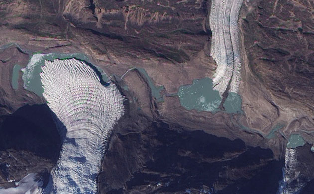
Small glaciers spill into a mostly dry valley in western Greenland in this image. Multiple glaciers frequently flow into straight valleys in Greenland, which have been formed from earlier glaciations that carved the bedrock. The shallow, blue-green water in the valley bottom is likely laced with rock flour left over from earlier glacial grinding of Greenland's rocks
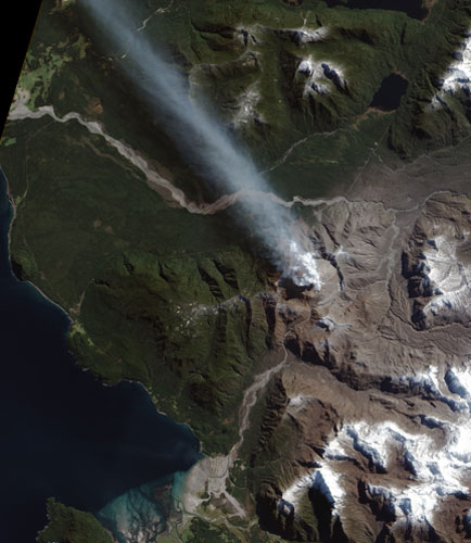
After a spectacular explosion in May 2008, Chile's Chaiten volcano has erupted continuously for the past 16 months. The arrival of spring in the southern hemisphere allowed this clear view of the ongoing eruption, which had been hidden by clouds for much of the winter. Chaiten is currently in a dome-building phase. Thick lava is erupting in Chaiten's caldera, slowly building a steep-sided dome. Eruptions of ash and steam occur when portions of the dome collapse. The town of Chaiten (located south of the volcano) remains evacuated due to the threat of flows of volcanic debris from the unstable dome
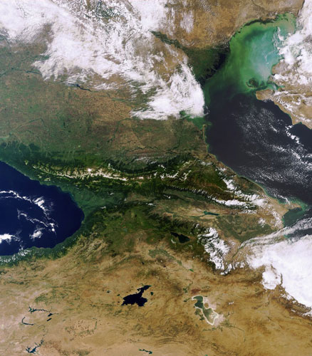
This image shows the Volga delta and Caucasus. The Volga delta (seen here as a fan shape in the top centre of the image) is the largest inland river delta in Europe, located where Europe's largest river system, the Volga, drains into the Caspian Sea on the Russian coast. The Caucasus - the strip of land in the centre - contains the Caucasus mountains, including Europe's highest mountain (Mount Elbrus) and is considered to be a dividing line between Asia and Europe. The Caucasus is an area of great ecological importance, home to some 6,400 species of plants, 1,600 of which are endemic to the region. Its wildlife includes leopards, brown bears, wolves, European bisons, marals, golden eagles and hooded crows
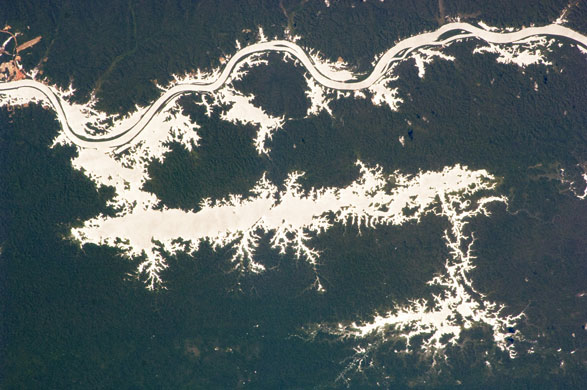
The 38km-long Lago do Erepecu (Lake Erepecu) in Brazil runs parallel to the lower Rio Trombetas (Trombetas river), which snakes along the lower half of this astronaut's photograph. Waterbodies in the Amazon rainforest are often so dark they can be difficult to distinguish. In this image, however, the lake and river stand out from the uniform green of the forest in great detail as a result of sun reflecting off water's surface
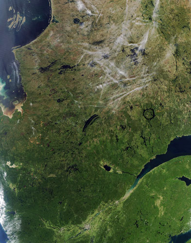
When the hot, humid air from a jet engine mixes with colder, drier air in the surrounding environment, condensation trails, or 'contrails', form in the sky. If the air through which the aeroplane is flying is already close to being saturated with water vapour, the condensation trail will last longer than when the air is dry. A contrail that lingers can spread out into a layer of cirrus (thin, wispy clouds). This image, captured on 9 September, shows a number of contrails above some notable geological features in an area of Quebec, Canada. One is the circular lake called the Manicouagan reservoir, seen here in the mid-right of the image. The lake is circular because it is the remnant of one of the Earth's largest preserved impact craters. Waters from Manicouagan eventually flow into the St Lawrence Bay - the large body of water near the bottom right of the image


1 comments:
Nice post - astronaut wallpaper ..Keep Posting
Ron
astronaut wallpaper
FreeWallpapers
Post a Comment